


Quick Takeaways
- Ohio stays sunny for the rest of Tuesday afternoon, with highs in the low to mid 50s and no rain expected.
- Tonight is mostly clear and cold, with lows in the upper 20s to mid 30s and patchy fog possible late.
- Wednesday is sunny and warmer, and dry weather holds through Saturday before a chance of rain on Sunday.
Ohio’s sunny afternoon holds for the rest of Tuesday, and the evening commute should be an easy one statewide. The National Weather Service (NWS) had no watches, warnings or advisories in effect in Ohio early this afternoon, skies stayed sunny from Lake Erie to the Ohio River, and temperatures reached the low to mid 50s on light south to southwest winds. There is no chance of rain for the rest of today.
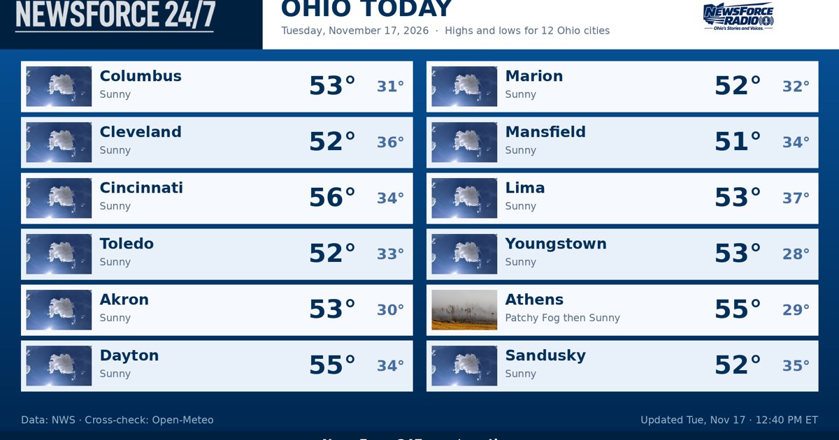
Highs for Tuesday are near 52 degrees in Toledo, Cleveland and Marion, 53 in Columbus, Akron, Lima and Youngstown, 55 in Dayton and Athens, and 56 in Cincinnati, the warmest reading in the state. Mansfield is the coolest spot at near 51, and Sandusky reaches near 52 along Lake Erie. Winds stay light through sunset, which comes shortly after 5 p.m. across Ohio at this time of year.
In the Northwest, Toledo and Lima stay sunny through the evening before skies turn mostly clear tonight, with lows near 33 in Toledo and near 37 in Lima. Across the Northeast, Cleveland, Akron and Youngstown also stay clear tonight. Lows fall to near 36 in Cleveland, near 30 in Akron and near 28 in Youngstown, the coldest low in the state tonight.
Central Ohio stays sunny for the rest of the afternoon in Columbus and Marion, then turns mostly clear tonight with lows near 31 in Columbus and near 32 in Marion. In the Southwest, Dayton and Cincinnati keep their sunshine into the evening and turn clear tonight, with lows near 34 in both cities. South winds around 5 miles per hour are expected tonight in the southern half of the state.
In the Southeast, Athens finishes a day that began with patchy fog with sunshine, then turns mostly clear tonight with a low near 29. That clear, calm and cold setup is the same one that produced fog the past two mornings. The Weather Service office in Cleveland says patchy fog is possible again tonight into Wednesday morning, especially in river valleys and other low-lying areas.
Drivers out late tonight or early Wednesday should be ready for visibility that can change quickly in fog, and for slick spots on bridges and overpasses if fog forms where temperatures are at or below freezing. Tonight itself brings no other travel hazards, and Wednesday morning conditions improve once any early fog lifts. The rest of Wednesday is sunny across Ohio.
Wednesday starts a steady warm-up under continued dry weather. Highs reach the upper 50s in the north, including near 56 in Toledo, and rise into the upper 50s to low 60s farther south, with Logan County in the upper 50s on south winds around 5 miles per hour. Wednesday night stays mostly clear, with lows in the upper 30s in central and southern Ohio.
Thursday is mostly sunny with highs in the lower 60s, Friday is sunny with highs in the mid 60s, and Saturday stays mostly sunny with highs in the mid 60s, according to the Weather Service offices in Cleveland and Wilmington (Ohio). The dry pattern does not break until Sunday, when parts of Ohio carry a 40 percent chance of rain with highs in the upper 50s. Cooler air follows on Monday, with highs only in the mid 40s.