


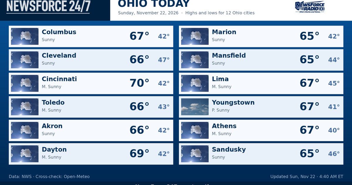
Ohio starts Sunday, November 22, 2026, under clear skies and calm to light winds for most of the state, with early temperatures in the low to upper 40s — 42 degrees in Columbus, 43 degrees in Cincinnati and 48 degrees in Cleveland, where a southerly breeze was already stirring along Lake Erie. The National Weather Service had no watches, warnings or advisories in effect for Ohio counties early Sunday, and the day ahead is the warmest and driest part of the forecast before a front brings rain tonight and much colder air for Monday, November 23, 2026.
By afternoon, sunshine mixing with increasing clouds and south winds will lift highs well above late-November norms statewide. Columbus is forecast to reach about 68 degrees, Cleveland about 67 degrees and Cincinnati near 69 to 71 degrees, with mid- to upper-60s expected across much of northwest, central and southeast Ohio as well. Rain chances stay near zero through the daylight hours, making Sunday the best window of the weekend for travel, errands and outdoor work.
In the northwest and along the lake shore, Toledo and Cleveland will see the steadiest breeze today, with south winds around 12 to 13 miles per hour and gusts near 20 miles per hour in northeast Ohio. Skies turn partly to mostly cloudy late in the day, but conditions stay dry until after dark. A Small Craft Advisory for Lake Erie is scheduled to take effect late Sunday night, at 11:00 PM, and run into Tuesday afternoon as winds and waves build behind the front.
Central and northeast Ohio stay mostly sunny to partly cloudy through the afternoon, with Columbus climbing from the 40s this morning into the upper 60s and Cleveland reaching the mid- to upper-60s despite the lake breeze. In the southeast, from Athens toward Marietta and Portsmouth, expect a similar warm, dry day with highs in the upper 60s, light morning winds turning southerly, and clouds thickening toward evening ahead of the approaching rain.
In the southwest, Cincinnati and Dayton have the warmest forecast in the state, with highs around 69 to 71 degrees under partly cloudy skies. That warmth does not last into the night. Showers are expected to reach southwest Ohio first, around 7:00 PM in the Cincinnati area, then spread east and north — reaching Columbus around 9:00 PM and Cleveland around 10:00 PM. Rainfall totals tonight look light, generally around seven-hundredths to nine-hundredths of an inch, enough to wet roads but not enough for flooding concerns.
Behind the rain, winds shift to the west and northwest overnight and temperatures fall steadily. Monday, November 23, 2026, will feel like a different season: highs only in the upper 40s to about 50 degrees statewide — roughly 20 degrees colder than Sunday — with northwest winds of 10 to 18 miles per hour and gusts of 20 to 28 miles per hour, especially in northern Ohio. Skies turn mostly sunny in central and southwest Ohio, and Monday night turns mostly clear and cold, with lows of 27 to 28 degrees in Columbus and Cincinnati.
Looking ahead, Tuesday, November 24, 2026, stays chilly and mostly sunny with highs in the mid-40s, then clouds increase Wednesday, November 25, 2026, with highs in the low 50s and rain arriving late ahead of Thanksgiving. Rain is likely on Thursday, November 26, 2026, with highs in the mid-40s, followed by cloudy, colder weather on Friday. For today, drivers should plan on a dry, warm Sunday, finish outdoor plans before the evening showers arrive, and be ready for wet roads tonight and a blustery, much colder start to the workweek on Monday.