


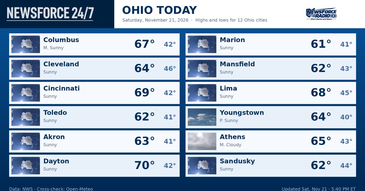
Ohio heads into a quiet, cool night on Saturday, November 21, 2026, after a sunny and seasonably warm day, and Sunday, November 22, 2026, brings one more warm day before a cold front changes the pattern late in the day. The National Weather Service offices serving Ohio reported no watches, warnings or advisories in effect anywhere in the state on Saturday evening, and forecasters in Wilmington and Cleveland described dry high pressure holding over the state tonight, with partly cloudy to mostly clear skies and overnight lows in the low to mid 40s.
That cool-down after sunset is part of the weekend pattern. The Weather Service in Wilmington said a broad ridge over the eastern United States has kept daytime highs in the 60s, while very dry air, with dewpoints in the 30s, has allowed temperatures to swing widely between day and night. Columbus was fair and near 57 degrees early Saturday evening after a high in the mid 60s, and readings across the state were set to fall into the 40s overnight, so a jacket is the right call for anyone out this evening.
In northwest Ohio, Toledo, Findlay and Defiance stay dry and partly cloudy tonight with lows around 40 to 43 degrees, then warm back into the mid 60s on Sunday. In northeast Ohio, Cleveland, Akron-Canton and Youngstown see a partly cloudy night with lows in the low to mid 40s, followed by Sunday highs in the low to mid 60s. On Lake Erie, the Weather Service in Cleveland said offshore winds around 10 knots and nearshore waves under 2 feet continue tonight and Sunday before the front arrives.
Central Ohio, including Columbus, stays partly cloudy tonight with a low around 41 to 43 degrees, then turns mostly sunny on Sunday with a high in the mid 60s. In southwest Ohio, Cincinnati, Dayton and Wilmington follow the same script, cool tonight with lows in the mid 40s and warm again on Sunday with highs in the mid 60s. In southeast Ohio and the Ohio River counties, tonight is dry and cool and Sunday is dry and warm, with clouds increasing later in the day ahead of the front.
Sunday stays dry for most of the daylight hours statewide, and that makes it the better half of the weekend for travel and outdoor plans. The change comes late Sunday into Sunday night, when a cold front crosses Ohio with rain showers. The Weather Service in Wilmington said the front will not draw in a large amount of moisture and will move through fairly quickly, so rainfall is expected to be light, a tenth of an inch or less at most locations. The Weather Service in Cleveland said non-flying weather conditions will be possible in the rain showers Sunday evening into Monday morning.
The air behind the front is sharply colder. Highs on Monday, November 23, 2026, fall into the 40s statewide, roughly 15 to 20 degrees below Sunday, and lows Monday night drop into the upper 20s and low 30s. On Lake Erie, winds turn northwesterly at 20 to 25 knots Sunday night behind the front, building waves to 5 to 7 feet through Monday night, with a Small Craft Advisory likely, the Weather Service in Cleveland said. Boaters should plan for that rapid change Sunday evening.
Tuesday, November 24, 2026, stays cold and dry with highs around 40 to 43 degrees, before the next chance for precipitation develops on Wednesday, November 25, 2026, and continues into Thursday, November 26, 2026. Forecasters said that later system could bring rain, with a chance that some wet snowflakes mix in depending on how the system develops. For tonight and Sunday, though, Ohio faces no severe weather and no travel warnings, just a cool night, a warm final day of the weekend, and rain arriving late enough that most Sunday plans should finish dry.